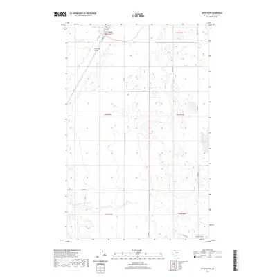
2020 Map of Kevin South
USGS Topo · Published 2020About this map
The settlement of Kevin anchors the northern edge of this Toole County landscape, where the high plains meet the intricate drainage patterns of the Montana frontier. The terrain is defined by dramatic erosional features like Alkali Flat Coulee and Potter Coulee, which carve through the open range south of the town center. Just north of the rail lines, the waters of Goeddertz Lake provide a rare catchment in this semi-arid environment. The map details a sophisticated grid of rural access routes named for local families and landmarks, such as Stevens Rd, Mozer Rd, and Kelleher Rd, which reflect the persistent agricultural and ranching legacy of the region. These roads connect dispersed homesteads across township boundaries like t34n r3w and t35n r2w, offering a clear view of land division and land use in the early twenty-first century.
Find a feature on this map
24 named features on this map. Tap any name to fly to it.
Don’t see what you’re looking for? This feature index may not catch every label — zoom into the map to look around manually.
Map Details
Editions of this 2020 Kevin South Map
This is the sole edition of this map. No revisions or reprints were ever made.
Other maps of this area

1909 · Cut Bank
USGS Topo · 1:125,000

1912 · Cut Bank
USGS Topo · 1:125,000

1939 · Sunburst
USGS Topo · 1:62,500

1943 · Shelby
USGS Topo · 1:62,500

1954 · Shelby
USGS Topo · 1:250,000

1958 · Shelby
USGS Topo · 1:250,000

1960 · Cut Bank
USGS Topo · 1:250,000

1963 · Cut Bank
USGS Topo · 1:250,000

1964 · Cut Bank
USGS Topo · 1:250,000
1966 · Ethridge
USGS Topo · 1:24,000