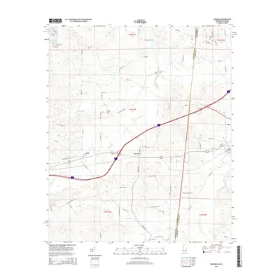
2015 Map of Kewanee
USGS Topo · Published 2015About this map
Toomsuba Cr and its tributaries carve a path through the borderlands between Mississippi and Alabama, defining the drainage patterns for the small communities of Kewanee and Cuba. This 2015 survey illustrates a landscape primarily shaped by timber and agriculture, crisscrossed by roads like Kewanee Rd and Cuba Rd. The area is notably dense with small family and community burial grounds, including Kelly Cem, Payne Cem, and Morning Star Cem, which serve as vital markers for local genealogical research. In the southern portion of the map, the settlement of Salem is located near Salem Cem and Salem Cr. The interstate and rail corridors cut through the terrain, connecting the rural holdings of Smith to the larger regional networks, while features like Roasted Hog Cr provide unique local landmarks in the northern reaches of the quadrangle.
Find a feature on this map
83 named features on this map. Tap any name to fly to it.
Don’t see what you’re looking for? This feature index may not catch every label — zoom into the map to look around manually.
Map Details
Editions of this 2015 Kewanee Map
This is the sole edition of this map. No revisions or reprints were ever made.
Other maps of this area

1921 · Meridian
USGS Topo · 1:48,000

1923 · Meridian
USGS Topo · 1:62,500

1953 · Meridian
USGS Topo · 1:250,000

1957 · Meridian
USGS Topo · 1:250,000

1962 · Lauderdale
USGS Topo · 1:24,000

1965 · Meridian
USGS Topo · 1:250,000

1971 · Vimville
USGS Topo · 1:24,000
1971 · Toomsuba
USGS Topo · 1:24,000

1974 · Boyd
USGS Topo · 1:24,000

1974 · Ward
USGS Topo · 1:24,000