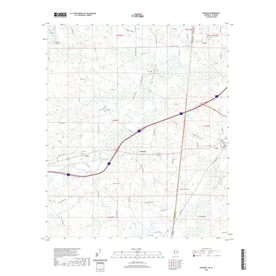
2020 Map of Kewanee
USGS Topo · Published 2020About this map
Mississippi and Alabama borderlands meet along this 2020 survey, where the township lines of Lauderdale and Sumter counties converge. The small settlement of Kewanee sits centrally, anchored by a network of rural routes like Kewanee Rd and Cuba Rd that bridge the interstate corridor. To the east, the town of Cuba is mapped with its street grid, featuring 7th Ave and Co Rd 10. The landscape is defined by the winding paths of Toomsuba Creek and Sucatoba Cr, while northern reaches are punctuated by Dalewood Shore Lake. For those researching local families, several small burial grounds are identified across the countryside, including Star Cem, Payne Cem, and Salem Cem. The terrain reflects a mix of low-lying wetlands around Roasted Hog Cr and the structured land divisions typical of the Deep South’s historical survey system.
Find a feature on this map
79 named features on this map. Tap any name to fly to it.
Don’t see what you’re looking for? This feature index may not catch every label — zoom into the map to look around manually.
Map Details
Editions of this 2020 Kewanee Map
This is the sole edition of this map. No revisions or reprints were ever made.
Other maps of this area

1921 · Meridian
USGS Topo · 1:48,000

1923 · Meridian
USGS Topo · 1:62,500

1953 · Meridian
USGS Topo · 1:250,000

1957 · Meridian
USGS Topo · 1:250,000

1962 · Lauderdale
USGS Topo · 1:24,000

1965 · Meridian
USGS Topo · 1:250,000

1971 · Vimville
USGS Topo · 1:24,000
1971 · Toomsuba
USGS Topo · 1:24,000

1974 · Boyd
USGS Topo · 1:24,000

1974 · Ward
USGS Topo · 1:24,000