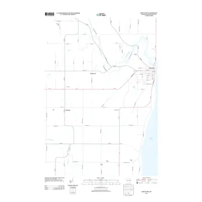
2013 Map of Kewaunee
USGS Topo · Published 2013About this map
The city of Kewaunee sits at the mouth of the Kewaunee River where it meets the vast expanse of Lake Michigan. This 2013 survey captures the interplay of lakeshore geography and the region's deep agricultural roots. The interior is defined by numerous family-named agricultural operations and dairy sites, such as Elm Grove Dairy Farm, Halls Calf Ranch, and Sano Farms. These holdings follow a rectilinear grid of county highways and local lanes that cut across the meandering paths of Krok Cr and the E Twin River.
Find a feature on this map
75 named features on this map. Tap any name to fly to it.
Don’t see what you’re looking for? This feature index may not catch every label — zoom into the map to look around manually.
Map Details
Editions of this 2013 Kewaunee Map
This is the sole edition of this map. No revisions or reprints were ever made.
Other maps of this area

1952 · Casco
USGS Topo · 1:62,500

1954 · Kewaunee
USGS Topo · 1:62,500

1954 · Manitowoc
USGS Topo · 1:250,000

1958 · Manitowoc
USGS Topo · 1:250,000

1960 · Algoma
USGS Topo · 1:62,500

1978 · Casco
USGS Topo · 1:24,000

1978 · Stangelville
USGS Topo · 1:24,000
1978 · Luxemburg
USGS Topo · 1:24,000
1978 · Larrabee
USGS Topo · 1:24,000
1978 · Kewaunee
USGS Topo · 1:24,000