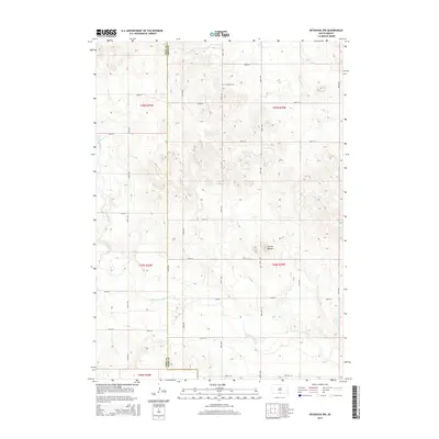
2015 Map of Keyapaha NW
USGS Topo · Published 2015About this map
The Keya Paha River winds through the southern reaches of this landscape, marking a significant hydrologic divide on the border between Todd and Tripp Counties. In the north, the small Jerusalem Cem serves as a lone historical marker amidst the section lines of the South Dakota prairie. The topography is defined by the Dorian Buttes, which rise above the surrounding plains near the center of the survey. Drainage patterns are further shaped by the presence of Willow Cr in the northeast and Crazy Hole Cr to the west. The area's development is structured by a rigorous grid of section-line roads, including 287th St and 300th Ave, illustrating the enduring influence of the Public Land Survey System on the rural landscape.
Find a feature on this map
26 named features on this map. Tap any name to fly to it.
Don’t see what you’re looking for? This feature index may not catch every label — zoom into the map to look around manually.
Map Details
Editions of this 2015 Keyapaha NW Map
This is the sole edition of this map. No revisions or reprints were ever made.
Other maps of this area

1955 · Martin
USGS Topo · 1:250,000

1958 · Martin
USGS Topo · 1:250,000

1982 · Witten SE
USGS Topo · 1:25,000

1982 · Keyapaha SE
USGS Topo · 1:24,000

1982 · Witten SW
USGS Topo · 1:25,000
1982 · Clearfield
USGS Topo · 1:24,000

1982 · Hidden Timber SE
USGS Topo · 1:24,000

1982 · Okreek SE
USGS Topo · 1:24,000
1982 · Keyapaha NW
USGS Topo · 1:24,000
1982 · Hidden Timber NE
USGS Topo · 1:24,000