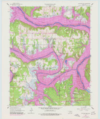
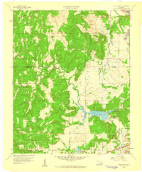
1958 Map of Keystone Dam
USGS Topo · Published 1977About this map
Keystone Lake dominates this landscape where the Arkansas River and Cimarron River converge, reflecting a period of significant hydrological and infrastructural change. Purple photorevisions from 1967 indicate the massive impact of the inundation, highlighting areas like the Cowskin Bay Recreation Area and Appalachia Bay Recreation Area that emerged as the shoreline shifted. The relocation of settlements is evidenced by New Mannford, situated near the St Louis - San Francisco railroad line. Local history is preserved in the locations of Dixie Cem, Sinnett Cem, and the Rigsby Sch, while the rural economy is marked by numerous Oil Wells scattered across the Cimarron and Hominy terrain. The map also identifies aviation history at the Keystone Landing Strip and recreational development within Keystone State Park.
Find a feature on this map
44 named features on this map. Tap any name to fly to it.
Don’t see what you’re looking for? This feature index may not catch every label — zoom into the map to look around manually.
Map Details
Editions of this 1958 Keystone Dam Map
4 editions found
Other maps of this area

1912 · Hominy
USGS Topo · 1:125,000

1915 · Hominy
USGS Topo · 1:125,000

1915 · Hominy
USGS Topo · 1:62,500

1955 · Enid
USGS Topo · 1:250,000

1958 · Enid
USGS Topo · 1:250,000

1958 · Keystone Dam
USGS Topo · 1:24,000
1958 · Mannford SE
USGS Topo · 1:24,000

1958 · Wekiwa
USGS Topo · 1:24,000
1959 · Lake Sahoma
USGS Topo · 1:24,000

1966 · Cleveland
USGS Topo · 1:24,000