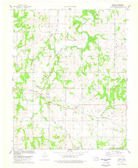
1978 Map of Casey
USGS Topo · Published 1978About this map
Black Bear Creek meanders through this Pawnee County landscape, defining the topography of a region shaped by both heavy industry and agricultural transit in the late 1970s. The map illustrates a complex intersection of infrastructure where the Atchison Topeka and Santa Fe and the St Louis San Francisco railroads cross the territory, meeting at points like Esau Junction. This era of the landscape is heavily marked by energy and resource extraction, evidenced by the extensive Oil Field operations, the Harper Field, and multiple Quarries located near Cody.
Find a feature on this map
23 named features on this map. Tap any name to fly to it.
Don’t see what you’re looking for? This feature index may not catch every label — zoom into the map to look around manually.
Map Details
Editions of this 1978 Casey Map
This is the sole edition of this map. No revisions or reprints were ever made.
Other maps of this area

1929 · Yale
USGS Topo · 1:62,500

1929 · Ripley
USGS Topo · 1:62,500

1929 · Skedee
USGS Topo · 1:62,500

1930 · Pawnee
USGS Topo · 1:62,500

1931 · Skedee
USGS Topo · 1:62,500

1932 · Yale
USGS Topo · 1:62,500

1932 · Ripley
USGS Topo · 1:62,500

1936 · Pawnee
USGS Topo · 1:62,500

1955 · Enid
USGS Topo · 1:250,000

1958 · Enid
USGS Topo · 1:250,000