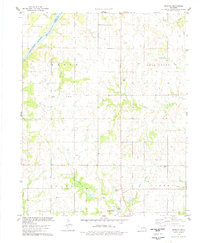
1978 Map of Masham
USGS Topo · Published 1978About this map
The Arkansas River carves the northwestern corner of this landscape, marking the historic Osage Indian Res Bdy and the transition between Osage Co and Pawnee Co. This 1978 survey of the north-central Oklahoma plains captures an area defined by the early 20th-century petroleum boom, evidenced by a broad Oil Field and numerous scattered Oil Wells. The small community of Masham serves as a local anchor near Masham Cem, while the town of Skedee sits further south along the namesake Skedee Creek. Grounded in ranching and resource extraction, the map also features Big Hill and the Pawnee Municipal Airport, illustrating the evolution of local transportation and topography near the banks of Coal Creek and Eagle Creek.
Find a feature on this map
26 named features on this map. Tap any name to fly to it.
Don’t see what you’re looking for? This feature index may not catch every label — zoom into the map to look around manually.
Map Details
Editions of this 1978 Masham Map
This is the sole edition of this map. No revisions or reprints were ever made.
Other maps of this area

1929 · Skedee
USGS Topo · 1:62,500

1930 · Pawnee
USGS Topo · 1:62,500

1931 · Skedee
USGS Topo · 1:62,500

1932 · Fairfax
USGS Topo · 1:62,500

1936 · Belford
USGS Topo · 1:62,500

1936 · Pawnee
USGS Topo · 1:62,500

1955 · Enid
USGS Topo · 1:250,000

1958 · Enid
USGS Topo · 1:250,000
1978 · Prettyhair Creek
USGS Topo · 1:24,000
1978 · Pawnee
USGS Topo · 1:24,000