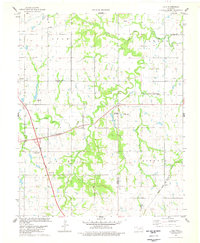
1978 Map of Lela
USGS Topo · Published 1978About this map
Black Bear Creek meanders deeply through this prairie landscape on the border of Pawnee and Noble counties. The small settlement of Lela sits at the heart of the map, situated at the junction of the St Louis - San Francisco railroad and local roads. The area shows a significant petroleum and utility infrastructure, with an Oil Well, Gas Well, and Drill Hole scattered among the sections, alongside several pipelines crossing the northern terrain.
Find a feature on this map
29 named features on this map. Tap any name to fly to it.
Don’t see what you’re looking for? This feature index may not catch every label — zoom into the map to look around manually.
Map Details
Editions of this 1978 Lela Map
This is the sole edition of this map. No revisions or reprints were ever made.
Other maps of this area

1893 · Stillwater
USGS Topo · 1:62,500

1929 · Ripley
USGS Topo · 1:62,500

1930 · Pawnee
USGS Topo · 1:62,500

1932 · Ripley
USGS Topo · 1:62,500

1936 · Pawnee
USGS Topo · 1:62,500

1955 · Enid
USGS Topo · 1:250,000

1958 · Enid
USGS Topo · 1:250,000
1967 · Stillwater North
USGS Topo · 1:24,000

1972 · Morrison NE
USGS Topo · 1:24,000

1972 · Morrison
USGS Topo · 1:24,000