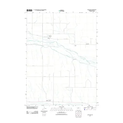
2011 Map of Keystone
USGS Topo · Published 2011About this map
The North Platte River and the South Platte River define the northern and southern boundaries of this Keith County landscape, illustrating the critical role of water in the Nebraska plains. Central to the area is the Sutherland Canal, which bypasses the braided channels of the North Platte to support local irrigation and power needs. The small community of Keystone serves as a northern hub, anchored by the Keystone Post Office, while Roscoe and its corresponding Roscoe Post Office sit along the southern river corridor.
Find a feature on this map
28 named features on this map. Tap any name to fly to it.
Don’t see what you’re looking for? This feature index may not catch every label — zoom into the map to look around manually.
Map Details
Editions of this 2011 Keystone Map
This is the sole edition of this map. No revisions or reprints were ever made.
Other maps of this area

1897 · Ogallala
USGS Topo · 1:125,000

1898 · Paxton
USGS Topo · 1:125,000

1900 · Ogallala
USGS Topo · 1:125,000

1901 · Paxton
USGS Topo · 1:125,000

1954 · North Platte
USGS Topo · 1:250,000

1956 · North Platte
USGS Topo · 1:250,000

1957 · North Platte
USGS Topo · 1:250,000

1967 · North Platte
USGS Topo · 1:250,000

1971 · Martin
USGS Topo · 1:24,000
1971 · Ogallala SW
USGS Topo · 1:24,000