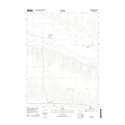
2014 Map of Keystone
USGS Topo · Published 2014About this map
Keystone and Broganville occupy the high ground between the meandering North Platte River and the engineered corridor of the Sutherland Canal. This landscape in central Nebraska is defined by the heavy management of water, where the canal cuts a straight line across the topography south of the river's natural braids. Further south, the settlement of Roscoe sits along the historic route of Us-30, positioned just north of the South Platte River. The map reveals a distinct contrast between the organic paths of Spring Cr and Whitetail Cr and the rigid grid of county roads like Road E 160 and Road E 120. This 2014 survey documents the enduring spatial relationship between the twin Platte rivers and the transport infrastructure that connects these small prairie communities.
Find a feature on this map
22 named features on this map. Tap any name to fly to it.
Don’t see what you’re looking for? This feature index may not catch every label — zoom into the map to look around manually.
Map Details
Editions of this 2014 Keystone Map
This is the sole edition of this map. No revisions or reprints were ever made.
Other maps of this area

1897 · Ogallala
USGS Topo · 1:125,000

1898 · Paxton
USGS Topo · 1:125,000

1900 · Ogallala
USGS Topo · 1:125,000

1901 · Paxton
USGS Topo · 1:125,000

1954 · North Platte
USGS Topo · 1:250,000

1956 · North Platte
USGS Topo · 1:250,000

1957 · North Platte
USGS Topo · 1:250,000

1967 · North Platte
USGS Topo · 1:250,000

1971 · Martin
USGS Topo · 1:24,000
1971 · Ogallala SW
USGS Topo · 1:24,000