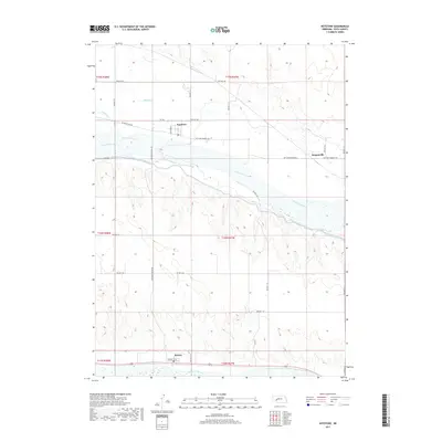
2017 Map of Keystone
USGS Topo · Published 2017About this map
The North Platte River and South Platte River define the hydraulic character of this Keith County landscape, carving parallel paths across the plains. Between these two major waterways, the Sutherland Canal cuts a distinct industrial line, part of the region's managed water network. The settlement of Keystone sits at a junction of regional routes like Keystone Lake Rd and Keystone Sarben Rd, while the southern edge of the map is anchored by the community of Roscoe along Roscoe 1st St. Smaller tributaries such as Whitetail Creek and Spring Cr feed into the river systems, illustrating the drainage patterns that have shaped local agriculture and transit. The map reveals a high density of rural section roads, including Rd East 170 and Rd 160, which trace the grid-based development of the Nebraska panhandle.
Find a feature on this map
23 named features on this map. Tap any name to fly to it.
Don’t see what you’re looking for? This feature index may not catch every label — zoom into the map to look around manually.
Map Details
Editions of this 2017 Keystone Map
This is the sole edition of this map. No revisions or reprints were ever made.
Other maps of this area

1897 · Ogallala
USGS Topo · 1:125,000

1898 · Paxton
USGS Topo · 1:125,000

1900 · Ogallala
USGS Topo · 1:125,000

1901 · Paxton
USGS Topo · 1:125,000

1954 · North Platte
USGS Topo · 1:250,000

1956 · North Platte
USGS Topo · 1:250,000

1957 · North Platte
USGS Topo · 1:250,000

1967 · North Platte
USGS Topo · 1:250,000

1971 · Martin
USGS Topo · 1:24,000
1971 · Ogallala SW
USGS Topo · 1:24,000