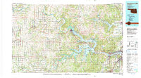
1990 Map of Keystone Lake
USGS Topo · Published 1990About this map
The confluence of the Arkansas River and Cimarron River defines this landscape, which is dominated by the sprawling waters of Keystone Lake. This 1990 edition captures the intricate shoreline and surrounding infrastructure of the Osage Indian Reservation and several adjacent counties. The region's industrial character is clearly visible through numerous Oil Field designations that dot the terrain between established settlements like Pawnee and Cleveland.
Find a feature on this map
63 named features on this map. Tap any name to fly to it.
Don’t see what you’re looking for? This feature index may not catch every label — zoom into the map to look around manually.
Map Details
Editions of this 1990 Keystone Lake Map
This is the sole edition of this map. No revisions or reprints were ever made.
Other maps of this area

1893 · Stillwater
USGS Topo · 1:62,500

1896 · Okmulgee
USGS Topo · 1:125,000

1900 · Okmulgee
USGS Topo · 1:125,000

1901 · Claremore
USGS Topo · 1:125,000

1901 · Nowata
USGS Topo · 1:125,000

1901 · Nuyaka
USGS Topo · 1:125,000

1908 · Agra
USGS Topo · 1:62,500

1909 · Perkins
USGS Topo · 1:62,500

1909 · Pawhuska
USGS Topo · 1:125,000

1910 · Pawhuska
USGS Topo · 1:125,000