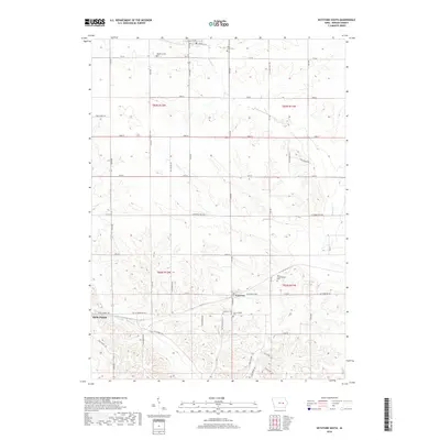
2018 Map of Keystone South
USGS Topo · Published 2018About this map
Luzerne and the northern reaches of Belle Plaine anchor this rural landscape in Benton County, where the township structure of the Iowa prairie remains visible through a grid of secondary roads and local county trunks. The terrain is defined by the winding paths of Prairie Creek and Buckeye Creek, which influence the placement of early settlements and agricultural holdings. Genealogists will find a concentration of burial sites reflecting the area's sectarian and pioneer history, including the Holy Cross Cemetery, Lutheran Cemetery, and Keystone Cemetery. The map also captures the path of Willow Brook and the transition between several township ranges, including t83n r12w and t82n r11w, illustrating how the 19th-century Public Land Survey System continues to dictate the modern rural layout.
Find a feature on this map
33 named features on this map. Tap any name to fly to it.
Don’t see what you’re looking for? This feature index may not catch every label — zoom into the map to look around manually.
Map Details
Editions of this 2018 Keystone South Map
This is the sole edition of this map. No revisions or reprints were ever made.
Other maps of this area

1954 · Waterloo
USGS Topo · 1:250,000

1954 · Des Moines
USGS Topo · 1:250,000

1955 · Waterloo
USGS Topo · 1:250,000

1956 · Des Moines
USGS Topo · 1:250,000

1957 · Des Moines
USGS Topo · 1:250,000

1965 · Ladora
USGS Topo · 1:24,000

1965 · Keystone South
USGS Topo · 1:24,000
1965 · Marengo
USGS Topo · 1:24,000
1965 · Blairstown
USGS Topo · 1:24,000

1968 · Belle Plaine
USGS Topo · 1:24,000