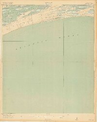
1918 Map of Kiawah Island
USGS Topo · Published 1918About this map
Kiawah Island is captured here as a largely undeveloped barrier island during the First World War, defined by its primary thoroughfare, Avenue Road, and the intricate marshes of the Kiawah River. The shoreline reaches out to Sandy Point in the east, where the land fragments into a series of smaller landforms like Cinder Point and Eagle Point near the mouth of Bass Creek. This 1:21,120 scale survey, produced by the U.S. Geological Survey in cooperation with the War Department, provides an exacting look at the coastal topography before modern resort development altered the landscape. To the north, the southern edge of Johns Island is visible across the river, while the vast expanse of the Atlantic Ocean dominates the southern half of the sheet, illustrating the isolation of this sea island at the time of the survey.
Find a feature on this map
10 named features on this map. Tap any name to fly to it.
Don’t see what you’re looking for? This feature index may not catch every label — zoom into the map to look around manually.
Map Details
Editions of this 1918 Kiawah Island Map
2 editions found
Other maps of this area

1918 · Kiawah Island
USGS Topo · 1:21,120

1919 · Wadmelaw Island
USGS Topo · 1:62,500

1919 · James Island
USGS Topo · 1:21,120

1919 · Legareville
USGS Topo · 1:21,120

1943 · Legareville
USGS Topo · 1:24,000

1943 · James Island
USGS Topo · 1:24,000

1943 · Kiawah Island
USGS Topo · 1:24,000

1944 · Wadmelaw Island
USGS Topo · 1:62,500

1947 · Savannah
USGS Topo · 1:250,000

1948 · James Island
USGS Topo · 1:250,000