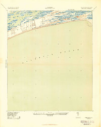
1943 Map of Kiawah Island
USGS Topo · Published 1943About this map
Kiawah Island is depicted during a pivotal wartime era, based on 1939 aerial photography and older 1918 ground surveys. This survey by the War Department and Corps of Engineers reveals the island as a largely undeveloped barrier landscape before the era of modern resort expansion. The map detail highlights the intricate marshlands and tidal channels that separate the island from Johns Island to the north, defined by the winding Kiawah River.
Find a feature on this map
9 named features on this map. Tap any name to fly to it.
Don’t see what you’re looking for? This feature index may not catch every label — zoom into the map to look around manually.
Map Details
Editions of this 1943 Kiawah Island Map
2 editions found
Other maps of this area

1918 · Kiawah Island
USGS Topo · 1:21,120

1919 · Wadmelaw Island
USGS Topo · 1:62,500

1919 · James Island
USGS Topo · 1:21,120

1919 · Legareville
USGS Topo · 1:21,120

1943 · Legareville
USGS Topo · 1:24,000

1943 · James Island
USGS Topo · 1:24,000

1943 · Kiawah Island
USGS Topo · 1:24,000

1944 · Wadmelaw Island
USGS Topo · 1:62,500

1947 · Savannah
USGS Topo · 1:250,000

1948 · James Island
USGS Topo · 1:250,000