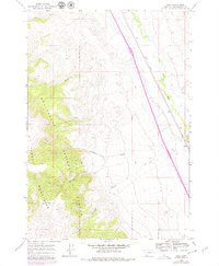
1965 Map of Kidd
USGS Topo · Published 1979About this map
The Union Pacific railroad corridor and the Red Rock River anchor this topographic study of southwestern Montana, where the valley floor meets the high peaks of the Beaverhead Mountains and Tendoy Mountains. The small settlement of Kidd stands along the rail line, serving as a focal point for the surrounding ranching and transport landscape. This 1965 survey, updated in 1979, illustrates a transition between the irrigated valley bottoms and the protected timberlands of the Beaverhead National Forest. Drainage patterns are defined by deep cuts such as Bell Canyon, McKenzie Canyon, and Limekiln Canyon, while McKnight Creek flows through the southern reaches of the quadrangle. The map captures the infrastructure of the late 20th century, including a Rest Area and various Gravel Pit sites, reflecting the intersection of interstate transit and local resource extraction.
Find a feature on this map
14 named features on this map. Tap any name to fly to it.
Don’t see what you’re looking for? This feature index may not catch every label — zoom into the map to look around manually.
Map Details
Editions of this 1965 Kidd Map
2 editions found
Other maps of this area

1955 · Dubois
USGS Topo · 1:250,000

1958 · Dubois
USGS Topo · 1:250,000
1965 · Garfield Canyon
USGS Topo · 1:24,000

1965 · Kidd
USGS Topo · 1:24,000
1965 · Monument Hill
USGS Topo · 1:24,000

1965 · Briggs Ranch
USGS Topo · 1:24,000
1965 · Red Rock
USGS Topo · 1:24,000

1965 · Graphite Mountain
USGS Topo · 1:24,000

1965 · Deer Canyon
USGS Topo · 1:24,000

1965 · Dixon Mountain
USGS Topo · 1:24,000