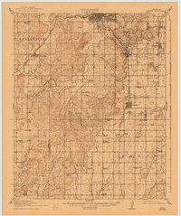
1916 Map of Kiefer
USGS Topo · Published 1943About this map
Sapulpa stands as a significant rail and commercial hub in this 1914 survey of the Oklahoma oil region, situated at the junction of the St Louis and San Francisco railroad lines. The landscape reflects the early 20th-century petroleum boom, specifically marked by Oil Tanks clustered near Kiefer and Glenpool. Beyond the industrial centers, the map documents a dense network of rural infrastructure including Picket School, Louisiana Baptist Church, and Grayson Church, serving the agricultural communities between Kellyville and Mounds. Drainage across the region is defined by the winding paths of Polecat Creek and the various branches of Duck Creek. This survey captures the transition from a dispersed frontier settlement pattern to a structured township system, evidenced by the proliferation of neighborhood institutions like Bluebell School and Pleasant Valley School that anchored local life before the modern consolidation of these rural districts.
Find a feature on this map
57 named features on this map. Tap any name to fly to it.
Don’t see what you’re looking for? This feature index may not catch every label — zoom into the map to look around manually.
Map Details
Editions of this 1916 Kiefer Map
3 editions found
Other maps of this area

1896 · Okmulgee
USGS Topo · 1:125,000

1900 · Okmulgee
USGS Topo · 1:125,000

1901 · Claremore
USGS Topo · 1:125,000

1901 · Nuyaka
USGS Topo · 1:125,000

1912 · Hominy
USGS Topo · 1:125,000

1914 · Kiefer
USGS Topo · 1:62,500

1914 · Claremore
USGS Topo · 1:125,000

1915 · Hominy
USGS Topo · 1:125,000

1916 · Kiefer
USGS Topo · 1:62,500

1916 · Claremore
USGS Topo · 1:125,000