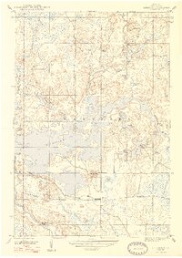
1947 Map of Kiernan
USGS Topo · Published 1947About this map
The Michigamme Reservoir dominates this Iron County landscape, its sprawling reach flooding the confluence of the Fence River and the Michigamme River. Established during the wartime mobilization of the mid-1940s, the reservoir and the Way Dam represent a significant transformation of the local hydrology for hydroelectric power. Along the southern shore, the settlement of Kiernan serves as a small focal point near the Chicago Milwaukee St Paul and Pacific rail line, which cuts an east-west path across the map.
Find a feature on this map
26 named features on this map. Tap any name to fly to it.
Don’t see what you’re looking for? This feature index may not catch every label — zoom into the map to look around manually.
Map Details
Editions of this 1947 Kiernan Map
2 editions found
Other maps of this area

1895 · Ned Lake
USGS Topo · 1:62,500

1899 · Sagola
USGS Topo · 1:62,500

1899 · Witbeck
USGS Topo · 1:62,500

1899 · Crystal Falls
USGS Topo · 1:62,500

1944 · Crystal Falls
USGS Topo · 1:24,000

1945 · Kelso Junction
USGS Topo · 1:24,000

1946 · Crystal Falls
USGS Topo · 1:31,680

1947 · Kiernan
USGS Topo · 1:24,000

1947 · Lake Mary
USGS Topo · 1:24,000

1947 · Kelso Junction
USGS Topo · 1:24,000