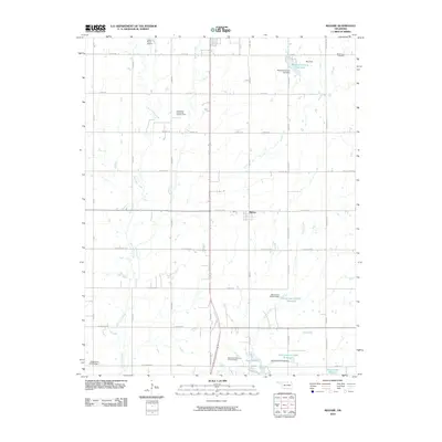
2010 Map of Kildare
USGS Topo · Published 2010About this map
Kildare serves as a central hub in this section of Kay County, situated in a landscape defined by its agricultural grid and petroleum development. The industrial character of the region is anchored by the Northwest Kildare Oil and Gas Field, which occupies several sections northwest of the town. For genealogists, the map preserves the location of Wolf Creek Cemetery in the northeast and Resthaven Memorial Park Cemetery near the southern boundary, providing essential data for local family histories. Water management is a prominent theme throughout the quadrangle, evidenced by a series of named reservoirs and dams including Schrickram Reservoir and the numbered Oknoname structures. To the south, the northern reaches of Lake Ponca and the neighboring Sky Park indicate areas of recreation and community focus, while Grass Roots Airport suggests the continued importance of small-scale aviation in the rural Oklahoma plains.
Find a feature on this map
50 named features on this map. Tap any name to fly to it.
Don’t see what you’re looking for? This feature index may not catch every label — zoom into the map to look around manually.
Map Details
Editions of this 2010 Kildare Map
This is the sole edition of this map. No revisions or reprints were ever made.
Other maps of this area

1935 · Kaw
USGS Topo · 1:62,500

1936 · Belford
USGS Topo · 1:62,500

1955 · Enid
USGS Topo · 1:250,000

1958 · Enid
USGS Topo · 1:250,000

1963 · Charley Creek
USGS Topo · 1:24,000

1963 · Uncas
USGS Topo · 1:24,000

1963 · Kaw City NW
USGS Topo · 1:24,000

1968 · Ponca City NW
USGS Topo · 1:24,000
1968 · Newkirk
USGS Topo · 1:24,000

1968 · Kildare
USGS Topo · 1:24,000