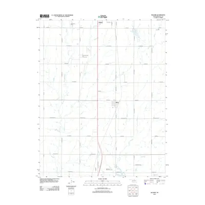
2012 Map of Kildare
USGS Topo · Published 2012About this map
Kildare and the southern edge of Newkirk anchor this Kay County landscape, a region defined by its orthogonal road grid and deep ties to the energy industry. The Northwest Kildare Oil and Gas Field occupies a central position west of the main thoroughfare, illustrating the continued significance of petroleum extraction in this part of Oklahoma. The terrain is drained by several seasonal watercourses, including Bois d'Arc Cr, Spring Cr, and Turkey Cr, which meander through the agricultural plots. Local community landmarks are visible in the form of the Grass Roots Airport and the Newkirk Country Club Lake, while genealogy researchers can identify the Wolf Creek Cem in the northeast and Resthaven Memorial Park Cem near the southern boundary, providing precise locations for family history work in the Ponca City area.
Find a feature on this map
47 named features on this map. Tap any name to fly to it.
Don’t see what you’re looking for? This feature index may not catch every label — zoom into the map to look around manually.
Map Details
Editions of this 2012 Kildare Map
This is the sole edition of this map. No revisions or reprints were ever made.
Other maps of this area

1935 · Kaw
USGS Topo · 1:62,500

1936 · Belford
USGS Topo · 1:62,500

1955 · Enid
USGS Topo · 1:250,000

1958 · Enid
USGS Topo · 1:250,000

1963 · Charley Creek
USGS Topo · 1:24,000

1963 · Uncas
USGS Topo · 1:24,000

1963 · Kaw City NW
USGS Topo · 1:24,000

1968 · Ponca City NW
USGS Topo · 1:24,000
1968 · Newkirk
USGS Topo · 1:24,000

1968 · Kildare
USGS Topo · 1:24,000