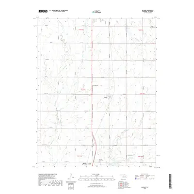
2018 Map of Kildare
USGS Topo · Published 2018About this map
Kildare sits at the heart of this North Central Oklahoma landscape, serving as a quiet crossroads between the larger hubs of Newkirk to the north and the northern edge of Ponca City to the south. The terrain is defined by a dense network of sectional roads and a series of southward-flowing waterways, including Bois d'Arc Cr, Spring Cr, and Turkey Cr, which drain the prairie toward the Arkansas River basin. Near the southern boundary, the map shows the transition into more developed land with Resthaven Memorial Park and the upper reaches of Lake Ponca. This 2018 survey reveals a landscape where traditional agricultural divisions, marked by numerous rural routes like W Doolin Ave and Kildare Rd, meet modern water management features such as 071026 Reservoir. The presence of the Wolf Creek Cem in the northeast corner provides a specific point of interest for genealogists tracing local family history in Kay County.
Find a feature on this map
54 named features on this map. Tap any name to fly to it.
Don’t see what you’re looking for? This feature index may not catch every label — zoom into the map to look around manually.
Map Details
Editions of this 2018 Kildare Map
This is the sole edition of this map. No revisions or reprints were ever made.
Other maps of this area

1935 · Kaw
USGS Topo · 1:62,500

1936 · Belford
USGS Topo · 1:62,500

1955 · Enid
USGS Topo · 1:250,000

1958 · Enid
USGS Topo · 1:250,000

1963 · Charley Creek
USGS Topo · 1:24,000

1963 · Uncas
USGS Topo · 1:24,000

1963 · Kaw City NW
USGS Topo · 1:24,000

1968 · Ponca City NW
USGS Topo · 1:24,000
1968 · Newkirk
USGS Topo · 1:24,000

1968 · Kildare
USGS Topo · 1:24,000