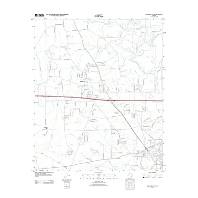
2013 Map of Kilgore NW
USGS Topo · Published 2013About this map
Liberty City serves as the central hub of this East Texas landscape, situated at a crossroads just north of the interstate corridor. The surrounding terrain is defined by a complex network of waterways that drain into the Sabine River along the northern edge of the survey, including the winding courses of Little Caney Cr, Peavine Cr, and Rocky Cr. Low-lying wetlands and floodplain features like Horseshoe Lake and Merrills Lake punctuate the river bottomlands, contrasting with the local rise of Goodman Mtn to the southwest. For those researching local heritage, the map is a primary record of rural community landmarks, documenting several significant burial grounds such as Mt Pleasant Cem, Strong Memorial Cem, and Moriah Cem. The road network preserves historical routes like the Old Kilgore Hwy and Old Gladewater Rd, reflecting the area's development between these two major regional centers.
Find a feature on this map
179 named features on this map. Tap any name to fly to it.
Don’t see what you’re looking for? This feature index may not catch every label — zoom into the map to look around manually.
Map Details
Editions of this 2013 Kilgore NW Map
This is the sole edition of this map. No revisions or reprints were ever made.
Other maps of this area

1936 · Kilgore
USGS Topo · 1:48,000

1938 · Winona
USGS Topo · 1:48,000

1940 · Kilgore
USGS Topo · 1:62,500

1943 · Winona
USGS Topo · 1:62,500

1956 · Tyler
USGS Topo · 1:250,000

1960 · Big Sandy
USGS Topo · 1:24,000

1960 · White Oak
USGS Topo · 1:24,000

1960 · Gladewater
USGS Topo · 1:24,000

1966 · Hope Pond
USGS Topo · 1:24,000
1966 · Starrville
USGS Topo · 1:24,000