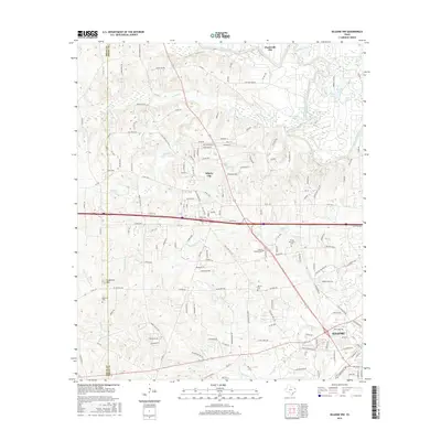
2016 Map of Kilgore NW
USGS Topo · Published 2016About this map
Kilgore sits at the southern edge of this landscape where the Smith and Gregg county lines meet, marking a region of East Texas defined by its rolling topography and numerous tributaries. The northern boundary is traced by the Sabine River, which feeds into a network of wetlands and small water bodies including Merrills Lake and Horseshoe Lake. The settlement patterns of Liberty City and Clarksville City are clustered near major thoroughfares, while the rural areas are dotted with local landmarks like Goodman Mtn. Genealogists will find several significant burial sites across the quadrangle, including Mount Pleasant Cem, Strong Memorial Cem, and Moriah Cem. The drainage system is particularly dense here, with Rabbit Cr, Peavine Cr, and Prairie Cr carving through the terrain, reflecting the hydrology of the Piney Woods region.
Find a feature on this map
161 named features on this map. Tap any name to fly to it.
Don’t see what you’re looking for? This feature index may not catch every label — zoom into the map to look around manually.
Map Details
Editions of this 2016 Kilgore NW Map
This is the sole edition of this map. No revisions or reprints were ever made.
Other maps of this area

1936 · Kilgore
USGS Topo · 1:48,000

1938 · Winona
USGS Topo · 1:48,000

1940 · Kilgore
USGS Topo · 1:62,500

1943 · Winona
USGS Topo · 1:62,500

1956 · Tyler
USGS Topo · 1:250,000

1960 · Big Sandy
USGS Topo · 1:24,000

1960 · White Oak
USGS Topo · 1:24,000

1960 · Gladewater
USGS Topo · 1:24,000

1966 · Hope Pond
USGS Topo · 1:24,000
1966 · Starrville
USGS Topo · 1:24,000