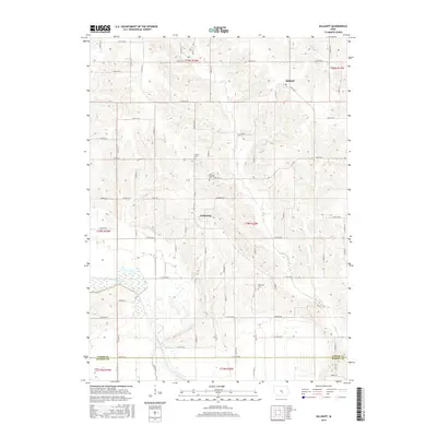
2015 Map of Killduff
USGS Topo · Published 2015About this map
Killduff and Galesburg anchor this rural landscape in southeast Jasper County, where the topography is defined by the winding course of the South Skunk River. The map reveals a deeply etched drainage pattern featuring Elk Creek, Little Elk Creek, and Slater Creek cutting through the upland prairies. Local history is preserved in several family and community burial grounds, including Hewitt Cem, Saint Andrews Cem, and Dearinger Cem, which are tucked away along section lines and secondary roads like Hwy F62 E. Near the southern border with Marion County, Kleins Cem sits near the river's floodplain. The rectilinear road grid, dominated by routes such as Hwy T22 S and S 64th Ave E, reflects the enduring agricultural structure of the township, punctuated only by these small clusters of settlement and cemetery sites.
Find a feature on this map
67 named features on this map. Tap any name to fly to it.
Don’t see what you’re looking for? This feature index may not catch every label — zoom into the map to look around manually.
Map Details
Editions of this 2015 Killduff Map
This is the sole edition of this map. No revisions or reprints were ever made.
Other maps of this area

1909 · Knoxville
USGS Topo · 1:62,500

1910 · Pella
USGS Topo · 1:62,500

1912 · Knoxville
USGS Topo · 1:62,500

1912 · Pella
USGS Topo · 1:62,500

1954 · Des Moines
USGS Topo · 1:250,000

1956 · Des Moines
USGS Topo · 1:250,000

1957 · Des Moines
USGS Topo · 1:250,000

1965 · Newton
USGS Topo · 1:24,000

1965 · Monroe
USGS Topo · 1:24,000
1965 · Otley
USGS Topo · 1:24,000
Featured Places
- Richland Township, IA
- Lake Prairie Township, IA
- Summit Township, IA
- Buena Vista Township, IA
- Palo Alto Township, IA