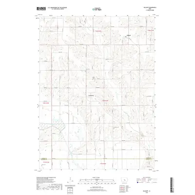
2018 Map of Killduff
USGS Topo · Published 2018About this map
Killduff and Galesburg anchor this rural Jasper County landscape, situated amidst a dense network of sectional roads and creek valleys. The terrain is defined by the drainage of the South Skunk River, which cuts across the southwest corner, and the meandering paths of Elk Cr and Little Elk Cr. These waterways influenced early settlement patterns and the placement of the area's rural burial grounds. Genealogists and local historians can locate several historic resting places, including Hewitt Cem and Saint Andrews Cem near the center of the sheet, as well as Dearinger Cem further south. The map reflects a classic Iowa agricultural grid, where roads like S 84th Ave E and Hwy T14 S connect small communities and farmsteads across the undulating prairie.
Find a feature on this map
67 named features on this map. Tap any name to fly to it.
Don’t see what you’re looking for? This feature index may not catch every label — zoom into the map to look around manually.
Map Details
Editions of this 2018 Killduff Map
This is the sole edition of this map. No revisions or reprints were ever made.
Other maps of this area

1909 · Knoxville
USGS Topo · 1:62,500

1910 · Pella
USGS Topo · 1:62,500

1912 · Knoxville
USGS Topo · 1:62,500

1912 · Pella
USGS Topo · 1:62,500

1954 · Des Moines
USGS Topo · 1:250,000

1956 · Des Moines
USGS Topo · 1:250,000

1957 · Des Moines
USGS Topo · 1:250,000

1965 · Newton
USGS Topo · 1:24,000

1965 · Monroe
USGS Topo · 1:24,000
1965 · Otley
USGS Topo · 1:24,000
Featured Places
- Richland Township, IA
- Lake Prairie Township, IA
- Summit Township, IA
- Buena Vista Township, IA
- Palo Alto Township, IA