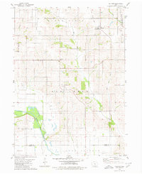
1980 Map of Killduff
USGS Topo · Published 1980About this map
Killduff and Galesburg serve as the primary social centers for this rural Iowa landscape as it appeared in the late 1970s. The terrain is defined by the winding course of the South Skunk River as it cuts across the southwestern corner, joined by tributaries including Elk Creek, Little Elk Creek, and Reasnor Creek. These waterways dictate the local geography, creating a series of wooded valleys and ridges that interrupt the dominant agricultural grid.
Find a feature on this map
17 named features on this map. Tap any name to fly to it.
Don’t see what you’re looking for? This feature index may not catch every label — zoom into the map to look around manually.
Map Details
Editions of this 1980 Killduff Map
This is the sole edition of this map. No revisions or reprints were ever made.
Other maps of this area

1909 · Knoxville
USGS Topo · 1:62,500

1910 · Pella
USGS Topo · 1:62,500

1912 · Knoxville
USGS Topo · 1:62,500

1912 · Pella
USGS Topo · 1:62,500

1954 · Des Moines
USGS Topo · 1:250,000

1956 · Des Moines
USGS Topo · 1:250,000

1957 · Des Moines
USGS Topo · 1:250,000

1965 · Newton
USGS Topo · 1:24,000

1965 · Monroe
USGS Topo · 1:24,000
1965 · Otley
USGS Topo · 1:24,000
Featured Places
- Summit Township, IA
- Lake Prairie Township, IA
- Palo Alto Township, IA
- Elk Creek Township, IA
- Richland Township, IA