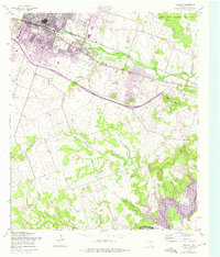
1958 Map of Killeen
USGS Topo · Published 1975About this map
Killeen stands as a rapidly expanding urban center in Central Texas, its growth reaching toward the Fort Hood Military Reservation boundary. This mid-century view captures the transition of the landscape as suburban development moves southward from the Atchison Topeka and Santa Fe rail line, displacing former ranch land. The southern portion of the quadrangle is defined by the Stillhouse Hollow Lake and the winding course of the Lampasas River, where the elevation rises into the Douglas Mountains. Notable infrastructure includes a massive Aqueduct project and the Killeen Municipal Airport. Local education and community roots are documented through several neighborhood institutions like East Ward Sch, Fowler Sch, and Pleasant Hill Ch, while the Lone Star settlement provides a look at smaller residential clusters before total urban integration.
Find a feature on this map
26 named features on this map. Tap any name to fly to it.
Don’t see what you’re looking for? This feature index may not catch every label — zoom into the map to look around manually.
Map Details
Editions of this 1958 Killeen Map
Other maps of this area

1893 · Georgetown
USGS Topo · 1:125,000

1894 · Gatesville
USGS Topo · 1:125,000

1924 · Gatesville 4-d
USGS Topo · 1:48,000

1924 · Gatesville 4-a
USGS Topo · 1:48,000

1930 · Killeen
USGS Topo · 1:62,500

1947 · Fort Hood
USGS Topo · 1:62,500

1947 · Bland
USGS Topo · 1:24,000

1947 · Fort Hood
USGS Topo · 1:24,000

1947 · Post Oak Mountain
USGS Topo · 1:24,000

1947 · Killeen
USGS Topo · 1:62,500