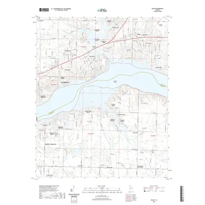
2020 Map of Killen
USGS Topo · Published 2020About this map
Wilson Lake dominates the central landscape of this Alabama survey, serving as the geographic divide between Florence and Muscle Shoals. The northern bank is characterized by a dense network of residential developments such as Rivermont, Bellemeade, and Lakeside Acres, while the southern shore transitions into the industrial and agricultural corridors of Listerhill and the uniquely named Nitrate City. This juxtaposition highlights the region's twentieth-century evolution from a river-focused economy to a major manufacturing and residential hub.
Find a feature on this map
114 named features on this map. Tap any name to fly to it.
Don’t see what you’re looking for? This feature index may not catch every label — zoom into the map to look around manually.
Map Details
Editions of this 2020 Killen Map
This is the sole edition of this map. No revisions or reprints were ever made.
Other maps of this area

1914 · Rogersville
USGS Topo · 1:48,000

1914 · Muscle Shoals
USGS Topo · 1:48,000

1916 · Muscle Shoals
USGS Topo · 1:62,500

1916 · Rogersville
USGS Topo · 1:62,500

1924 · Tuscumbia
USGS Topo · 1:48,000

1926 · Tuscumbia
USGS Topo · 1:62,500

1936 · Pruitton
USGS Topo · 1:24,000

1936 · Wheeler Dam
USGS Topo · 1:24,000

1936 · Florence
USGS Topo · 1:24,000

1936 · Town Creek
USGS Topo · 1:24,000