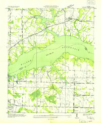
1936 Map of Killen
USGS Topo · Published 1936About this map
Wilson Reservoir dominates this 1936 landscape, a newly engineered aquatic environment resulting from the Tennessee Valley Authority’s mid-century expansion. The map captures the infrastructure of modernization, with Tennessee Valley Authority Transmission Lines and power corridors cutting across the rural topography of Lauderdale and Colbert Counties. On the northern shores, the community of Killen and the adjacent East Killen serve as established hubs, while leisure developments like the Shoal Creek Fishing Camp and Brush Creek Camp indicate the river's shift toward recreation.
Find a feature on this map
41 named features on this map. Tap any name to fly to it.
Don’t see what you’re looking for? This feature index may not catch every label — zoom into the map to look around manually.
Map Details
Editions of this 1936 Killen Map
This is the sole edition of this map. No revisions or reprints were ever made.
Other maps of this area

1914 · Rogersville
USGS Topo · 1:48,000

1914 · Muscle Shoals
USGS Topo · 1:48,000

1916 · Muscle Shoals
USGS Topo · 1:62,500

1916 · Rogersville
USGS Topo · 1:62,500

1924 · Tuscumbia
USGS Topo · 1:48,000

1926 · Tuscumbia
USGS Topo · 1:62,500

1936 · Pruitton
USGS Topo · 1:24,000

1936 · Wheeler Dam
USGS Topo · 1:24,000

1936 · Florence
USGS Topo · 1:24,000

1936 · Town Creek
USGS Topo · 1:24,000