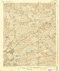
1937 Map of Killian
USGS Topo · Published 1937About this map
Fort Jackson Military Reservation and the sprawling grounds of Camp Jackson dominate the southern landscape of this 1930s survey, illustrating the significant military footprint in Richland County. The area is defined by a network of rural settlements and institutional landmarks, including the State Sanitarium and the Sand Hill Experimental Station. Small communities like Blythewood, Killian, and Blaney are connected by the Southern Railway and the Seaboard Air Line, which cut through a terrain of numerous creeks and family-named landmarks. The map documents a deeply established social fabric evidenced by dozens of rural congregations and schools such as Shady Grove Ch, Four O'Clock Ch, and the Jacob Mission Sch. Notable industrial and recreational sites like Lookmans Mill, the C C C Camp, and the Boy Scout Camp reflect the diverse land use in this period of South Carolina history.
Find a feature on this map
114 named features on this map. Tap any name to fly to it.
Don’t see what you’re looking for? This feature index may not catch every label — zoom into the map to look around manually.
Map Details
Editions of this 1937 Killian Map
4 editions found
Other maps of this area

1904 · Columbia
USGS Topo · 1:125,000

1935 · Camden
USGS Topo · 1:48,000

1935 · Killian
USGS Topo · 1:48,000

1937 · Killian
USGS Topo · 1:62,500

1938 · Camden
USGS Topo · 1:62,500

1938 · Hagood
USGS Topo · 1:62,500

1941 · Spartanburg
USGS Topo · 1:250,000

1942 · Camden
USGS Topo · 1:125,000

1943 · Eastover
USGS Topo · 1:62,500

1944 · Edmund
USGS Topo · 1:62,500