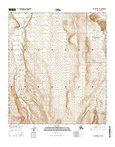
2016 Map of Killik River C-1 SE
USGS Topo · Published 2016About this map
Gates of the Arctic National Park encompasses the eastern edge of this landscape, where the high Arctic wilderness meets the headwaters of several significant drainages. The Okokmilaga River flows through the western sections, defining the drainage patterns of the North Slope in this remote region. Towards the northeast, May Lake sits atop a plateau, serving as a landmark in a terrain otherwise characterized by the braided paths of Pediment Cr and Fortress Cr. This 2016 survey illustrates the pristine environmental state of the Brooks Range foothills, showing the natural intersections of these waterways within the established township lines of t10s r6w and t10s r5w. The map provides an essential baseline for understanding the hydrography and topography of this protected interior wilderness.
Find a feature on this map
11 named features on this map. Tap any name to fly to it.
Don’t see what you’re looking for? This feature index may not catch every label — zoom into the map to look around manually.
Map Details
Editions of this 2016 Killik River C-1 SE Map
This is the sole edition of this map. No revisions or reprints were ever made.
Other maps of this area

1951 · Chandler Lake
USGS Topo · 1:250,000

1951 · Killik River
USGS Topo · 1:250,000

1956 · Chandler Lake
USGS Topo · 1:250,000

1956 · Killik River
USGS Topo · 1:250,000

1964 · Chandler Lake
USGS Topo · 1:250,000
1986 · Killik River B-1
USGS Topo · 1:63,360
1986 · Killik River C-1
USGS Topo · 1:63,360
1987 · Chandler Lake B-5
USGS Topo · 1:63,360
1987 · Chandler Lake C-5
USGS Topo · 1:63,360
2016 · Killik River B-1 NW
USGS Topo · 1:25,000