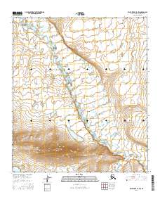
2016 Map of Killik River C-5 NW
USGS Topo · Published 2016About this map
The East Fork Etivluk River dominates the drainage of this North Slope landscape, winding north across the tundra in the central portion of this 2016 survey. This reach of the river represents a highly braided fluvial system, characteristic of the Arctic wilderness, where shallow channels shift across a broad gravelly floodplain. To the south, the topography rises more sharply where Iteriak Creek flows from the higher elevations of the foothills. The absence of roads or permanent settlements highlights the extreme isolation of this terrain within the t9s r17w and t8s r16w townships. For researchers of Alaskan geography, the map provides a precise record of hydrologic patterns and land contours before natural erosion or climate-driven changes alter the sensitive permafrost and stream paths of the Brooks Range foothills.
Find a feature on this map
6 named features on this map. Tap any name to fly to it.
Don’t see what you’re looking for? This feature index may not catch every label — zoom into the map to look around manually.
Map Details
Editions of this 2016 Killik River C-5 NW Map
This is the sole edition of this map. No revisions or reprints were ever made.
Other maps of this area

1951 · Howard Pass
USGS Topo · 1:250,000

1951 · Killik River
USGS Topo · 1:250,000

1956 · Howard Pass
USGS Topo · 1:250,000

1956 · Killik River
USGS Topo · 1:250,000

1984 · Howard Pass D-1
USGS Topo · 1:63,360

1984 · Howard Pass C-1
USGS Topo · 1:63,360

1984 · Killik River D-5
USGS Topo · 1:63,360
1984 · Killik River C-5
USGS Topo · 1:63,360
2016 · Howard Pass D-1 SE
USGS Topo · 1:25,000
2016 · Howard Pass C-1 NE
USGS Topo · 1:25,000