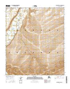
2016 Map of Killik River D-4 NE
USGS Topo · Published 2016About this map
Kurupa River defines the western corridor of this Arctic landscape, where it meanders through a broad valley floor before the terrain rises sharply into the high ridges of the North Slope. This 2016 survey documents a remote wilderness area characterized by significant elevation changes, with the southern reaches drained by Heather Creek. The map provides a precise look at the land's physical contours and hydrology as it existed in the early 21st century, showing the intersection of Township 5 South and Township 6 South. The lack of human settlements or infrastructure emphasizes the untouched nature of this subarctic environment, offering researchers a baseline for studying natural drainage patterns and the undisturbed geography of the Brooks Range foothills.
Find a feature on this map
6 named features on this map. Tap any name to fly to it.
Don’t see what you’re looking for? This feature index may not catch every label — zoom into the map to look around manually.
Map Details
Editions of this 2016 Killik River D-4 NE Map
This is the sole edition of this map. No revisions or reprints were ever made.
Other maps of this area

1951 · Ikpikpuk River
USGS Topo · 1:250,000

1951 · Killik River
USGS Topo · 1:250,000

1956 · Killik River
USGS Topo · 1:250,000

1956 · Ikpikpuk River
USGS Topo · 1:250,000
1984 · Ikpikpuk River A-4
USGS Topo · 1:63,360

1984 · Ikpikpuk River A-3
USGS Topo · 1:63,360
1986 · Killik River D-4
USGS Topo · 1:63,360
1986 · Killik River D-3
USGS Topo · 1:63,360
2016 · Killik River D-4 NW
USGS Topo · 1:25,000
2016 · Killik River D-4 SW
USGS Topo · 1:25,000