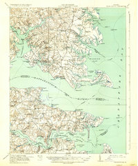
1917 Map of Kilmarnock
USGS Topo · Published 1937About this map
The Northern Neck and Middle Peninsula of Virginia meet the Chesapeake Bay in this 1916 survey, a landscape defined by its intricate shoreline and dependence on waterborne travel. Steamboat routes are clearly marked, connecting landings like Whitestone Wharf and Adam Wharf to the wider region before modern road networks dominated. The map captures a moment when local industry relied on sites like Duntons Mill and Barretts Mill, and community life centered around landmarks such as Christ Church, the Old Brick Church, and the County Fairgrounds near Kilmarnock.
Find a feature on this map
153 named features on this map. Tap any name to fly to it.
Don’t see what you’re looking for? This feature index may not catch every label — zoom into the map to look around manually.
Map Details
Editions of this 1917 Kilmarnock Map
4 editions found
Other maps of this area

1906 · Williamsburg
USGS Topo · 1:62,500

1916 · Kilmarnock
USGS Topo · 1:48,000

1916 · Mathews
USGS Topo · 1:62,500

1917 · Heathsville
USGS Topo · 1:48,000

1917 · Urbanna
USGS Topo · 1:62,500

1917 · Morattico
USGS Topo · 1:62,500

1917 · Kilmarnock
USGS Topo · 1:62,500

1917 · Ewell
USGS Topo · 1:62,500

1917 · Mathews
USGS Topo · 1:62,500

1918 · Morattico
USGS Topo · 1:62,500