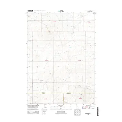
2013 Map of Kimama Butte
USGS Topo · Published 2013About this map
Kimama Butte and Sid Butte dominate this portion of the Snake River Plain, marking the volcanic geography of the high desert. This 2013 survey illustrates a landscape defined by water management and boundary lines where Jerome, Lincoln, and Minidoka counties meet. Small impoundments like Montrose Reservoir, Mustard Reservoir, Sid Reservoir, and Thrush Reservoir are critical infrastructure points in an otherwise arid expanse. The rectilinear grid of section lines and gravel roads, including Pole Line Rd and Senter Rd, shows the systematic division of public lands. The presence of Kimama Lookout Rd suggests the historical importance of the buttes as high-ground observation points for fire or range management in this desert environment.
Find a feature on this map
25 named features on this map. Tap any name to fly to it.
Don’t see what you’re looking for? This feature index may not catch every label — zoom into the map to look around manually.
Map Details
Editions of this 2013 Kimama Butte Map
This is the sole edition of this map. No revisions or reprints were ever made.
Other maps of this area

1954 · Pocatello
USGS Topo · 1:250,000

1955 · Twin Falls
USGS Topo · 1:250,000

1958 · Twin Falls
USGS Topo · 1:250,000

1958 · Pocatello
USGS Topo · 1:250,000

1964 · Burley NE
USGS Topo · 1:24,000

1964 · Burley NW
USGS Topo · 1:24,000

1964 · Hazelton NE
USGS Topo · 1:24,000

1971 · Owinza
USGS Topo · 1:24,000
1971 · Owinza Butte
USGS Topo · 1:24,000

1972 · Shale Butte
USGS Topo · 1:24,000