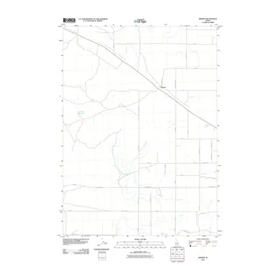
2010 Map of Kimama
USGS Topo · Published 2010About this map
Kimama sits at the intersection of rail and road infrastructure in this high desert region of Minidoka County. The settlement serves as a central hub for the surrounding agricultural landscape, where the grid of county roads like Kimama Carey Rd and 1600 North Rd organizes the territory. Water management is a defining characteristic of the local geography, evidenced by the Schrike Reservoir to the west and the engineered path of the F Main Drain to the southeast. These features reflect the intensive irrigation efforts necessary to sustain cultivation in southern Idaho's arid environment. The map captures a transition point where traditional rural routes meet the more rigid geometry of modern township and range divisions, providing a clear view of the area's mid-20th-century development pattern.
Find a feature on this map
31 named features on this map. Tap any name to fly to it.
Don’t see what you’re looking for? This feature index may not catch every label — zoom into the map to look around manually.
Map Details
Editions of this 2010 Kimama Map
This is the sole edition of this map. No revisions or reprints were ever made.
Other maps of this area

1954 · Pocatello
USGS Topo · 1:250,000

1958 · Pocatello
USGS Topo · 1:250,000

1964 · Burley NE
USGS Topo · 1:24,000

1964 · Rupert NW
USGS Topo · 1:24,000

1964 · Burley NW
USGS Topo · 1:24,000

1972 · Shale Butte
USGS Topo · 1:24,000

1972 · Kimama
USGS Topo · 1:24,000
1972 · Kimama Butte
USGS Topo · 1:24,000

1972 · Community Lake
USGS Topo · 1:24,000
1972 · Senter
USGS Topo · 1:24,000