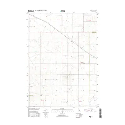
2017 Map of Kimama
USGS Topo · Published 2017About this map
Kimama sits at the center of this high desert landscape, positioned along a prominent corridor of road and rail infrastructure that cuts diagonally across the Snake River Plain. The terrain is defined by its volcanic geology and agricultural engineering, most notably the distinct circular landform of The Crater and the presence of the Schrike Reservoir to the west. This 2017 survey reveals the intricate grid of the Public Land Survey System, which governs the placement of long, straight thoroughfares such as E Senter Rd and Carey Kimama Rd. Irrigation and water management are central to the region's utility, evidenced by the F Main Drain passing through the southern sections. This map documents a sparsely populated but highly organized territory where the boundary between Lincoln and Minidoka counties meets a strictly regimented landscape of section lines and gravel roads.
Find a feature on this map
30 named features on this map. Tap any name to fly to it.
Don’t see what you’re looking for? This feature index may not catch every label — zoom into the map to look around manually.
Map Details
Editions of this 2017 Kimama Map
This is the sole edition of this map. No revisions or reprints were ever made.
Other maps of this area

1954 · Pocatello
USGS Topo · 1:250,000

1958 · Pocatello
USGS Topo · 1:250,000

1964 · Burley NE
USGS Topo · 1:24,000

1964 · Rupert NW
USGS Topo · 1:24,000

1964 · Burley NW
USGS Topo · 1:24,000

1972 · Shale Butte
USGS Topo · 1:24,000

1972 · Kimama
USGS Topo · 1:24,000
1972 · Kimama Butte
USGS Topo · 1:24,000

1972 · Community Lake
USGS Topo · 1:24,000
1972 · Senter
USGS Topo · 1:24,000