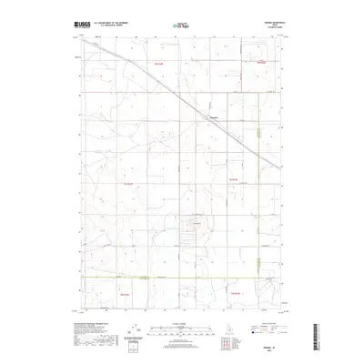
2020 Map of Kimama
USGS Topo · Published 2020About this map
Kimama sits at a critical junction of road and rail in the high desert of the Snake River Plain, where the Carey Kimama Rd meets the diagonal path of the Oregon Short Line railroad. This 2020 map documents a landscape defined by large-scale agricultural engineering and geological landmarks. To the south, The Crater dominates the local topography, a distinct volcanic feature surrounded by the rigid geometry of the Public Land Survey System.
Find a feature on this map
38 named features on this map. Tap any name to fly to it.
Don’t see what you’re looking for? This feature index may not catch every label — zoom into the map to look around manually.
Map Details
Editions of this 2020 Kimama Map
This is the sole edition of this map. No revisions or reprints were ever made.
Other maps of this area

1954 · Pocatello
USGS Topo · 1:250,000

1958 · Pocatello
USGS Topo · 1:250,000

1964 · Burley NE
USGS Topo · 1:24,000

1964 · Rupert NW
USGS Topo · 1:24,000

1964 · Burley NW
USGS Topo · 1:24,000

1972 · Shale Butte
USGS Topo · 1:24,000

1972 · Kimama
USGS Topo · 1:24,000
1972 · Kimama Butte
USGS Topo · 1:24,000

1972 · Community Lake
USGS Topo · 1:24,000
1972 · Senter
USGS Topo · 1:24,000