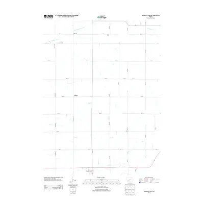
2013 Map of Kimballton
USGS Topo · Published 2013About this map
Kimballton serves as the primary settlement on this Audubon County landscape, positioned along the southern edge where local roads converge near the winding Indian Cr. The surrounding terrain is defined by a grid of agricultural section lines and several small watercourses, including Wolf Cr and Bull Run. In the northern half of the survey, the rural community of Fiscus and the Zinke Farm occupy the high ground near the E Br W Nishnabotna River. The map illustrates a contemporary pattern of land use where historic crossroads like Poplar remain as quiet markers of rural Iowa's settlement history. This 2013 record by the U.S. Geological Survey preserves the exact placement of local thoroughfares such as Bluebird Ave and Sharon Rd, offering a precise snapshot of the region's modern layout and its enduring water features like Lone Willow Cr.
Find a feature on this map
37 named features on this map. Tap any name to fly to it.
Don’t see what you’re looking for? This feature index may not catch every label — zoom into the map to look around manually.
Map Details
Editions of this 2013 Kimballton Map
This is the sole edition of this map. No revisions or reprints were ever made.
Other maps of this area

1954 · Omaha
USGS Topo · 1:250,000

1957 · Omaha
USGS Topo · 1:250,000

1957 · Audubon
USGS Topo · 1:62,500

1958 · Omaha
USGS Topo · 1:250,000

1971 · Gray
USGS Topo · 1:24,000

1978 · Elk Horn
USGS Topo · 1:24,000

1978 · Irwin
USGS Topo · 1:24,000

1978 · Kimballton
USGS Topo · 1:24,000

1978 · Prairie Rose Lake
USGS Topo · 1:24,000
1978 · Manning SE
USGS Topo · 1:24,000