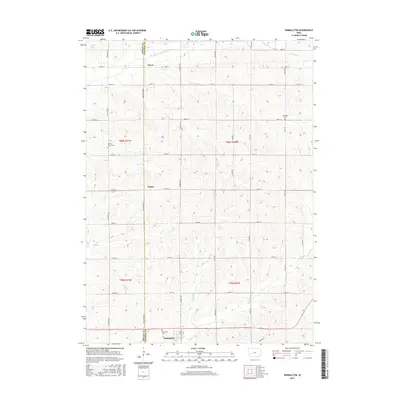
2015 Map of Kimballton
USGS Topo · Published 2015About this map
Kimballton serves as the primary hub at the southern edge of this West Central Iowa landscape, situated where the terrain begins its ascent from the Indian Cr valley. The map documents a predominantly agricultural region defined by a precise grid of section roads and the winding paths of several waterways, most notably the E Br West Nishnabotna River in the north and Wolf Cr in the west. Small historical settlements like Fiscus and Poplar are preserved here, providing essential reference points for researchers tracking the evolution of rural communities in Audubon and Shelby counties. Several local burial sites, including Merrills Grove Cem and Ebenezer Cem, offer significant genealogical value, marking the locations of early area congregations and family plots established long before modern consolidation.
Find a feature on this map
34 named features on this map. Tap any name to fly to it.
Don’t see what you’re looking for? This feature index may not catch every label — zoom into the map to look around manually.
Map Details
Editions of this 2015 Kimballton Map
This is the sole edition of this map. No revisions or reprints were ever made.
Other maps of this area

1954 · Omaha
USGS Topo · 1:250,000

1957 · Omaha
USGS Topo · 1:250,000

1957 · Audubon
USGS Topo · 1:62,500

1958 · Omaha
USGS Topo · 1:250,000

1971 · Gray
USGS Topo · 1:24,000

1978 · Elk Horn
USGS Topo · 1:24,000

1978 · Irwin
USGS Topo · 1:24,000

1978 · Kimballton
USGS Topo · 1:24,000

1978 · Prairie Rose Lake
USGS Topo · 1:24,000
1978 · Manning SE
USGS Topo · 1:24,000