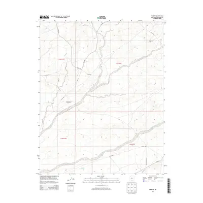
2013 Map of Kimbeto
USGS Topo · Published 2013About this map
Kimbeto and Nageezi anchor this high-desert landscape in the Eastern Navajo Agency, where the drainage patterns of Kimbeto Wash and Betonnie Tsosie Wash carve through the arid terrain. The map reveals a transitional era of infrastructure, balancing traditional rural access with industrial development as seen in the presence of Pipeline Rd. This network of local connectors, including Co Road 7830 and Indian Service Route 455, illustrates the critical role of transit corridors in this San Juan County region. Water management is sparse but vital, highlighted by features like the Hollow Pit Tank, which serves as a rare landmark in a geography defined by its seasonal washes and expansive township boundaries like t23n r10w.
Find a feature on this map
20 named features on this map. Tap any name to fly to it.
Don’t see what you’re looking for? This feature index may not catch every label — zoom into the map to look around manually.
Map Details
Editions of this 2013 Kimbeto Map
This is the sole edition of this map. No revisions or reprints were ever made.
Other maps of this area

1889 · Largo
USGS Topo · 1:250,000

1895 · Largo
USGS Topo · 1:250,000

1954 · Aztec
USGS Topo · 1:250,000

1958 · Aztec
USGS Topo · 1:250,000

1959 · Nageezi
USGS Topo · 1:62,500

1962 · Aztec
USGS Topo · 1:250,000

1965 · Aztec
USGS Topo · 1:250,000
1966 · Pueblo Bonito
USGS Topo · 1:24,000
1966 · Pueblo Bonito NW
USGS Topo · 1:24,000

1966 · Lybrook NW
USGS Topo · 1:24,000