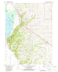
1981 Map of Kimsey Creek
USGS Topo · Published 1982About this map
Squaw Creek National Wildlife Refuge dominates the western lowlands of this Holt County landscape, where managed wetlands like the Sew Disp Pond and Minton marshlands sit adjacent to the Burlington Northern tracks. The terrain transitions sharply to the east into the loess hills of Benton and Hickory townships. This 1981 survey documents a rural environment where small settlements like Blair and Swope are secondary to the preservation of the flyway and the agricultural drainage systems of Davis Creek Ditch.
Find a feature on this map
37 named features on this map. Tap any name to fly to it.
Don’t see what you’re looking for? This feature index may not catch every label — zoom into the map to look around manually.
Map Details
Editions of this 1981 Kimsey Creek Map
This is the sole edition of this map. No revisions or reprints were ever made.
Other maps of this area

1885 · Atchison
USGS Topo · 1:125,000

1888 · Atchison
USGS Topo · 1:125,000

1893 · Atchison
USGS Topo · 1:125,000

1920 · Craig
USGS Topo · 1:62,500

1926 · Oregon
USGS Topo · 1:62,500

1926 · Maitland
USGS Topo · 1:62,500

1950 · Kansas City
USGS Topo · 1:250,000

1954 · Kansas City
USGS Topo · 1:250,000

1955 · Nebraska City
USGS Topo · 1:250,000

1956 · Kansas City
USGS Topo · 1:250,000