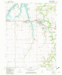
1982 Map of Kincaid
USGS Topo · Published 1983About this map
Industrial infrastructure and coal mining history define this Christian County landscape, where the Chicago and Illinois Midland railroad corridor links several small settlements. Kincaid, Tovey, and Bulpitt sit centrally on the map, their proximity to the South Fork Sangamon River and large mining operations like the Mine Dump and Mine Shaft near Jeisyville highlighting the area's mid-century economic drivers. To the west, the extensive waters of Sangchris Lake and the surrounding Sangchris Lake State Park provide a recreational contrast to the nearby Powerplant and Substation. The map preserves the locations of rural landmarks such as Bethany Cem and Goode Cem, alongside the agricultural patterns of Buckhart and King townships, reflecting a community balanced between heavy industry and central Illinois farmland.
Find a feature on this map
36 named features on this map. Tap any name to fly to it.
Don’t see what you’re looking for? This feature index may not catch every label — zoom into the map to look around manually.
Map Details
Editions of this 1982 Kincaid Map
This is the sole edition of this map. No revisions or reprints were ever made.
Other maps of this area

1922 · Divernon
USGS Topo · 1:62,500

1923 · Taylorville
USGS Topo · 1:62,500

1923 · Raymond
USGS Topo · 1:62,500

1924 · Divernon
USGS Topo · 1:62,500

1925 · Taylorville
USGS Topo · 1:62,500

1925 · Raymond
USGS Topo · 1:62,500

1946 · Nokomis
USGS Topo · 1:62,500

1949 · Nokomis
USGS Topo · 1:62,500

1958 · Decatur
USGS Topo · 1:250,000
1961 · New City
USGS Topo · 1:24,000