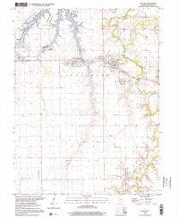
1998 Map of Kincaid
USGS Topo · Published 2002About this map
Sangchris Lake State Park dominates the northwest corner of this Christian County landscape, where the irregular shoreline of Sangchris Lake was meticulously mapped using depth data from earlier Commonwealth Edison Company records. The industrial and utility character of the region is evident near Sicily, featuring a Powerplant, Substation, and large Industrial Waste facilities. To the east, the Chicago & Illinois Midland RR cuts a path through the residential and commercial centers of Tovey, Bulpitt, and Kincaid, providing a vital link for the local economy. Evidence of the area's coal mining heritage appears in the form of a Mine Shaft and Mine Dump sites near Jeisyville. Away from the industrial corridor, the landscape transitions to the agricultural lands of Buckhart and King townships, where the Sangamon River and its South Fork provide the primary drainage. Local history is anchored by several small burial grounds, including Bethany Cem and Lutheran Cem.
Find a feature on this map
37 named features on this map. Tap any name to fly to it.
Don’t see what you’re looking for? This feature index may not catch every label — zoom into the map to look around manually.
Map Details
Editions of this 1998 Kincaid Map
This is the sole edition of this map. No revisions or reprints were ever made.
Other maps of this area

1922 · Divernon
USGS Topo · 1:62,500

1923 · Taylorville
USGS Topo · 1:62,500

1923 · Raymond
USGS Topo · 1:62,500

1924 · Divernon
USGS Topo · 1:62,500

1925 · Taylorville
USGS Topo · 1:62,500

1925 · Raymond
USGS Topo · 1:62,500

1946 · Nokomis
USGS Topo · 1:62,500

1949 · Nokomis
USGS Topo · 1:62,500

1958 · Decatur
USGS Topo · 1:250,000
1961 · New City
USGS Topo · 1:24,000