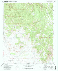
1979 Map of King Canyon
USGS Topo · Published 1985About this map
Prescott National Forest dominates this landscape, where the rugged topography transitions into the open expanse of Lonesome Valley. Historical evidence of early settlement and industry is scattered throughout the area, notably at a site marked Ruins near the Verde River and a small Prospect located near the base of St Matthews Mtn. The map highlights an extensive network of water resources essential for life in this arid region, including Gold Basin Well, King Well, and several named watering points like Duff Tank and Nunn Tank. Transportation history is visible in the southwest corner, where an Old Railroad Grade cuts across the valley floor. The convergence of King Canyon and Gold Basin illustrates the natural drainage patterns that have shaped the territory north of the Gila and Salt River Meridian.
Find a feature on this map
35 named features on this map. Tap any name to fly to it.
Don’t see what you’re looking for? This feature index may not catch every label — zoom into the map to look around manually.
Map Details
Editions of this 1979 King Canyon Map
3 editions found
Other maps of this area

1887 · Prescott
USGS Topo · 1:250,000

1892 · Prescott
USGS Topo · 1:250,000

1905 · Jerome
USGS Topo · 1:125,000

1944 · Clarkdale
USGS Topo · 1:48,000

1944 · Mingus Mountain
USGS Topo · 1:62,500

1947 · Mingus Mtn
USGS Topo · 1:62,500

1947 · Paulden
USGS Topo · 1:62,500

1947 · Prescott
USGS Topo · 1:62,500

1948 · Prescott
USGS Topo · 1:62,500
1948 · Clarkdale
USGS Topo · 1:62,500