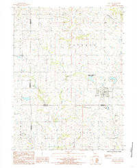
1984 Map of King City
USGS Topo · Published 1985About this map
King City serves as the primary hub of this northwestern Missouri landscape, situated at the junction of Gentry, Andrew, and De Kalb counties. The area is characterized by a dense network of watercourses, including the Platte River and its various tributaries such as Third Fork, Little Third Fork, and Elm Branch. A notable recreation spot appears at Limpp-Community State Lake, providing a contrast to the surrounding agricultural and township divisions of Jackson, Empire, and Polk. Evidence of past infrastructure is visible in the Old Railroad Grade cutting across the terrain, while modern utility corridors like the Wooden Pole Trans Line follow the topography. Local industry and rural infrastructure are represented by a Gravel Pit and a small Landing Strip, alongside several rural cemeteries scattered throughout the sections.
Find a feature on this map
22 named features on this map. Tap any name to fly to it.
Don’t see what you’re looking for? This feature index may not catch every label — zoom into the map to look around manually.
Map Details
Editions of this 1984 King City Map
This is the sole edition of this map. No revisions or reprints were ever made.
Other maps of this area

1923 · Clarksdale
USGS Topo · 1:62,500

1923 · Maysville
USGS Topo · 1:62,500

1925 · Clarksdale
USGS Topo · 1:62,500

1925 · Stanberry
USGS Topo · 1:62,500

1925 · Maysville
USGS Topo · 1:62,500

1925 · Darlington
USGS Topo · 1:62,500

1939 · Stanberry
USGS Topo · 1:62,500

1943 · Stanberry
USGS Topo · 1:62,500

1950 · Kansas City
USGS Topo · 1:250,000

1950 · Darlington
USGS Topo · 1:62,500