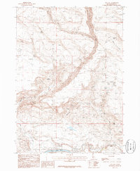
1986 Map of King Hill
USGS Topo · Published 1986About this map
King Hill serves as the focal point of this 1980s Elmore County survey, positioned where the Snake River meets a network of drainage systems. The landscape is defined by the sharp descent of the King Hill Creek and Hog Creek canyons as they carve through the volcanic plateau toward the river valley. The region's reliance on water management is evident through the distribution of numerous isolated water sources, including Buckbrush Spring, Twin Springs, and Corker Springs, alongside the Walker Reservoir. This environment includes distinctive landforms such as the Devils Playground and Kings Crown, which rise above the surrounding terrain. Technical infrastructure of the mid-1980s is also documented, including a Gaging Sta and Pump Sta on the riverbank, and a prominent Trans Line cutting across the upland draws.
Find a feature on this map
20 named features on this map. Tap any name to fly to it.
Don’t see what you’re looking for? This feature index may not catch every label — zoom into the map to look around manually.
Map Details
Editions of this 1986 King Hill Map
This is the sole edition of this map. No revisions or reprints were ever made.
Other maps of this area

1892 · Camas Prairie
USGS Topo · 1:125,000

1893 · Camas Prairie
USGS Topo · 1:125,000

1947 · Glenns Ferry
USGS Topo · 1:24,000

1947 · Pasadena Valley
USGS Topo · 1:24,000

1948 · Pasadena Valley
USGS Topo · 1:24,000

1948 · Glenns Ferry
USGS Topo · 1:24,000

1948 · Glenns Ferry
USGS Topo · 1:62,500

1948 · Ticeska
USGS Topo · 1:24,000

1949 · Ticeska
USGS Topo · 1:24,000

1949 · Pasadena Valley
USGS Topo · 1:62,500