
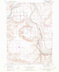
1947 Map of Pasadena Valley
USGS Topo · Published 1968About this map
The Snake River carves a deep path through Elmore County on this 1947 survey, revealing a landscape defined by volcanic geology and the essential movement of water. Below the towering Black Mesa, the Pasadena Valley serves as a pocket of agricultural activity, anchored by the Pasadena Valley Sch. The map reveals the intricate irrigation infrastructure necessary for life here, including the King Hill Main Canal and various siphons that move water across the uneven terrain.
Find a feature on this map
19 named features on this map. Tap any name to fly to it.
Don’t see what you’re looking for? This feature index may not catch every label — zoom into the map to look around manually.
Map Details
Editions of this 1947 Pasadena Valley Map
2 editions found
Other maps of this area

1892 · Camas Prairie
USGS Topo · 1:125,000

1893 · Camas Prairie
USGS Topo · 1:125,000

1947 · Glenns Ferry
USGS Topo · 1:24,000

1948 · Pasadena Valley
USGS Topo · 1:24,000

1948 · Glenns Ferry
USGS Topo · 1:24,000

1948 · Twentymile Butte
USGS Topo · 1:24,000

1948 · Glenns Ferry
USGS Topo · 1:62,500

1948 · Ticeska
USGS Topo · 1:24,000

1948 · Grindstone Butte
USGS Topo · 1:24,000
1949 · Grindstone Butte
USGS Topo · 1:24,000