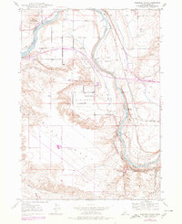
1947 Map of Pasadena Valley
USGS Topo · Published 1978About this map
Snake River canyon walls and the irrigated floor of Pasadena Valley define this mid-century portrait of Elmore County. The landscape preserves layers of western transit history, from the visible tracks of the Oregon Trail winding across the southern plateau to the Union Pacific railroad line following the river's path. Local settlement is anchored by the Pasadena Valley Sch, while the arid surroundings are punctuated by essential water sources like Bancroft Springs and Pilgrim Spr.
Find a feature on this map
16 named features on this map. Tap any name to fly to it.
Don’t see what you’re looking for? This feature index may not catch every label — zoom into the map to look around manually.
Map Details
Editions of this 1947 Pasadena Valley Map
2 editions found
Other maps of this area

1892 · Camas Prairie
USGS Topo · 1:125,000

1893 · Camas Prairie
USGS Topo · 1:125,000

1947 · Glenns Ferry
USGS Topo · 1:24,000

1947 · Pasadena Valley
USGS Topo · 1:24,000

1948 · Pasadena Valley
USGS Topo · 1:24,000

1948 · Glenns Ferry
USGS Topo · 1:24,000

1948 · Twentymile Butte
USGS Topo · 1:24,000

1948 · Glenns Ferry
USGS Topo · 1:62,500

1948 · Ticeska
USGS Topo · 1:24,000

1948 · Grindstone Butte
USGS Topo · 1:24,000